• Ancient Digger teaches Archaeology and History to all Ages!

Wednesday, August 24, 2011

Petoskey Stones Are Archaeological Artifacts


Several years ago I was staying in Mackinaw at my mother’s home on the water. On one occasion, I ventured out to the shore and started the daunting task of searching for fossils and shells. I stumbled upon what looked to be a Petoskey Stone, the state stone of Michigan. I was somewhat familiar with the geological make up, consisting of fossilized coral and other sea creatures. However, I never realized what kind of history was hidden beneath the outer core.

© danxcai

The Petoskey Stone is just one example of how sea life through history, captured in fossilized form, can provide insight into archaeological history. More specifically, Native Indian trade and tool making.

Source

The Legend of the Petoskey

According to legend, Petosegay was the child of a descendant of French nobleman and fur trader, Antoine Carre and an Ottawa princess. Petosegay, meaning "rising sun" "rays of dawn" or "sunbeams of promise", was named after the rays of sun that fell upon his newborn face. In keeping with his promising name, Petosegay was a wealthy fur trader who gained much land and acclaim for himself and his tribe. He was remarked upon to have a striking and appealing appearance, and spoke English very well. He married another Ottawa, and together they had two daughters and eight sons. In the summer of 1873, a few years before the Chiefs' passing, a city began on his land along the bay of Bear Creek. The settlers christened the newborn city Petoskey, the English translation of Petosegay.

The Town of Petoskey

Petoskey Stones are typically found in the town of Petoskey where several of the Nick Adams stories describing his summers on Walloon Lake were transcribed by Ernest Hemingway.

Petoskey was also the site where “Calliope”, the protagonist of Jeffrey Eugenides' Middlesex, is involved in some events that take a very severe direction. Eugenides was also known for his 1993 novel, The Virgin Suicides, which gained mainstream interest with the 1999 film adaptation directed by Sofia Coppola.

The town of Petoskey itself is most popular for its Petoskey Stone Festival where citizens celebrate a stone that is strictly native to Northern Michigan. The festival is a one of a kind display of decorative pieces, jewelry, and many other items crafted out of Petoskey stones.

Archaeological History of the Petosky Stone

Image via Wikipedia

Source

Phacopid trilobite from the Devonian

Source

During the Devonian Period, which occurred in the Paleozoic era, the first fish evolved legs and started to walk on land as tetrapods. Various terrestrial arthropods also became well-established. During this period, colony corals covered all of what is now the beautiful state of Michigan. Over time, the corals became fossilized and formed compacted sheets of rocks and were buried for centuries.

SEM image of a hederelloid from the Devonian of Michigan

Source

Later, the stones were formed as a result of glaciation, in which razor sharp sheets of ice plucked stones from the bedrock, grinding off their rough edges and depositing them in the northwestern portion of Michigan.

Source

If you happen to find these stones in dry form, they resemble ordinary limestone. However, when they are polished, the unique patterns emerge, taking on star like patterns with spikes. For the novice Geologist, the more angular in form these stones appear, the younger they are. If you happen to find a rounded and smooth stone, this will indicate that the stone itself has been exposed to more glacial erosion and weathering, and it’s much older than your angular find.

Interesting Fact: The name of the was derived from an Ottawa Indian Chief, Chief Pet-O-Sega. The town of Petoskey was named after him as well.

Friday, August 5, 2011

The Wilderness and Scenery of Fossil Springs in Arizona


This video of Fossil Springs in Arizona has a whole Journey to the Center of the Earth vibe. Diving off the rocky cliffs and swimming up and under this amazing geological wonder makes me really appreciate the natural processes of the earth.

Fossil Springs Arizona

Put together by the Traveling Bard, a graduate from the Walter Cronkite School of Journalism & Mass Communication at Arizona State University, and future archaeologist (so she just told me, how exciting!), you’ll look at Arizona from a entirely new perspective just by watching this.

If you’re not familiar with Fossil Springs Wilderness area in Arizona, you will be after this intimate journey. The wilderness area is located within the Coconino National Forest at the bottom of a steep canyon at the edge of the Colorado Plateau, just south of the Mogollon Rim. The water at Fossil Springs sustains one of the most diverse ecosystems in the state, with more than 30 species of trees set among native desert shrub. It also creates a haven for abundant wildlife.

Fossil springs in Coconino National Forest

Fossil springs in Arizona

Image sources

There was too much city in the trees so I took a day-trip up to Fossil Springs and hiked among green forests and crystal-clear creeks. ~The Traveling Bard

Wednesday, May 25, 2011

Adventures in Archaeology: IBM had a Problem


Guest Post By Geology Expert John Carter

Sometimes the use of GPR can be absolutely hilarious, consider this case in point. Several years ago IBM had a problem with a set of pipes carrying hydrogen gas from an above ground storage tank across the parking lot of their plant in East Fishkill, New York. The hydrogen is used in making computer chips. IBM had issued a contract for some archaeological excavation work to be performed in their parking lot. The contractor was given blueprints of the lot that showed two sets of pipes in different places after they had been told there were only one set of pipes.

Needless to say with the information supplied the contractor wasn’t sure of exactly where the pipes were. He became especially nervous after some of the officials at IBM had informed him that if he broke either of the pipes it would cost him $8 million a minute. He had heard about Ground Penetrating Radar, so he found out who manufactured the units, and put in a phone call to the manufacturer, Geophysical Survey Systems, Inc. of Salem, New Hampshire who had a policy of giving GPR jobs to the nearest owner of one of their units to the job site.


Presently we received a phone call from the contractor explaining his problem. We showed up bright and early the next morning with our unit, set the instrument up, selected the proper antenna for the job, and went trolling for the errant pipes. The antenna we selected looks for the entire world like a power lawnmower with an extension cord leading back to the unit in the van. After we had been going back and forth in the parking lot for a while we attracted some attention from the denizens inside the plant, and out came some junior executive who asked what we were doing.

We explained what we were looking for, and how the GPR unit worked, and with that he went back into the plant. About twenty minutes passed when several more executives came out from the plant including the general manager who invited us, and our GPR unit, to come back into the plant. We marked off with a can of spray paint where we stopped with the GPR survey, and followed them into the plant. The general manager explained to us they were having the same problem inside the plant with the same set of pipes, and they also having the same problem finding the pipes because they had two sets of prints showing the pipes in different locations.

IBM is one of the most high-tech companies in the world, but their best effort was a janitor with a pair of bent coat hangers dowsing for the pipes. We got an extra job out of the deal where everybody paid us by the hour for our services.


This is how GPR works: It is similar too your kitchen microwave in that it uses a cavity magnetometer to generate the radar micro waves, but the similarity to a microwave oven ends there. The power generated by a GPR unit is roughly 1/20,000 of the power generated by a microwave oven. The beam is not focused, so it is not like a searchlight, but more like a floodlight. GPR does not generate a sharp image like a camera, but rather an image produced by the radar waves acting against the difference in dielectric strength between the earth and any object buried in the ground. This produces an echo that is returned to the GPR unit that converts it to an image on some form of monitor where it can be interpreted by the operator into useful information about subsurface conditions. The readout can be either a digital image on a screen, from an archaeology site sometimes,  or a printout from a multichannel oscillograph.

Most GPR units use both systems together because the printout is hard copy that can be stored. The digital copy is also stored in some sort of device that stores memory.

Author Bio John Carter is a geologist that paid his way through college as a commercial helicopter pilot in the NY Metro area. He has had extensive experience as a prospector, and operated an environmental consulting firm specializing in environmental site assessments and is certified by the State of Connecticut as an Environmental Analyst III. In his early life he worked as an experimental machinist on aircraft and electronic parts before receiving his degree as a geologist. Carter also owns the website Gold Mining and Prospecting.

More of John Carter’s Articles

How to Layout a Claim with GPS

I own a Garmin 90 handheld GPS unit that is designed for use in aircraft that although it doesn’t have all the “bells and whistles” as newer models used for navigating on the ground even so it is quite capable of accurately laying out property lines, and corner locations that is exactly what is called for to layout and stake a claim.
How to Layout a Claim with GPS

Use of GPR at the L’Ambiance Plaza Disaster

L’Ambiance Plaza was a 16 story residential project that was under construction in Bridgeport, Connecticut at the corner of Washington Avenue and Coleman Street when its partial frame collapsed on April 23, 1987. There were 28 workers that were killed, caught between the sandwiched concrete floors of the collapsed building. The site was immediately swarmed by many of the construction workers from other projects in Bridgeport who tried to save trapped workers. From the start it was quite apparent that finding any survivors would be a miracle.
The Darker Side of Archaeology: Use of GPR at the L’Ambiance Plaza Disaster

The Environmental Site Assessment as an Archeological Study

An environmental site assessment (ESA) is a report mandated by law designed to establish the well being of any piece of property that in practice usually applies to commercial and/or industrial properties. An ESA is divided into three parts called phases that are numbered I, II and III. A Phase I report is used to determine whether or not the possibility of a release of hazardous material has in fact occurred on a property by determining its prior history.
The Environmental Site Assessment as an Archeological Study

Resources
Photos are in Public Domain

Sunday, May 15, 2011

The Darker Side of Archaeology: Use of GPR at the L’Ambiance Plaza Disaster


L’Ambiance Plaza was a 16 story residential project that was under construction in Bridgeport, Connecticut at the corner of Washington Avenue and Coleman Street when its partial frame collapsed on April 23, 1987. There were 28 workers that were killed, caught between the sandwiched concrete floors of the collapsed building. The site was immediately swarmed by many of the construction workers from other projects in Bridgeport who tried to save trapped workers. From the start it was quite apparent that finding any survivors would be a miracle.

This photo taken at the scene of the disaster illustrates what kind of problems we faced using GPR.
(This photo taken at the scene of the disaster illustrates what kind of problems we faced using GPR.)

Shortly after the accident we received a phone call from the Bridgeport Police requesting us to come to the accident scene as soon as possible with our Ground Penetrating Radar (GPR) to join in the search for survivors. As soon as we arrived at the scene of the collapse we set up our GPR unit and quickly discovered that although our unit had the capability of penetrating several feet into the ground, it was unable to penetrate the concrete used in the construction of L'Ambiance Plaza.

The construction methods that were used totally defeated the GPR because the floors were reinforced with rebar and heavy wire mesh. It was impossible to penetrate the concrete and get any meaningful images as a result of the very strong echoes from the steel reinforcements.

Strangely, the next job we received was determining if there were sufficient reinforcements of rebar in a construction project in the neighboring city of Norwalk, Connecticut. In this case the GPR was effective because the rebar was far enough apart, so the solar radar beam did not pick up any conflicting echoes.

This brings up the question of where you can't use GPR, and there are several different natural conditions that can block the radar beam.

The GPR is virtually useless in the following conditions:
  • In concrete that is heavily enforced with rebar or wire mesh or any combination of both.
  • If the soil is contaminated with salt; the salt will have a tendency to break up the radar beam causing a very shallow penetration that at times can be measured in millimeters making the use of GPR virtually impossible.
  • The presence of excessive clay serves practically the same purpose since the penetration of the radar beam through clay can also be measured in millimeters.

Forensic-gpr-subsurface-inspection

(This shows a GPR unit at work at a forensic site)

Fortunately there are other places where GPR can be used to great effect. It can be used very effectively in penetrating solid stone. One of the early trials we conducted with ground penetrating radar was the Palisade Sill in New Jersey across the river from New York City. The radar beam penetrated to about 300 feet and showed the deposits of chromite that had settled through the molten basaltic magma from which the sill is composed.

5_areas_of_concern1a
(This is a readout showing five areas of interest that might be human remains. )

We have also used GPR to detect cavities in limestone underlying a stretch of Interstate 80 in western New Jersey. Some of these cavities were as small as a teacup and others were as large as a small house. The average depth of penetration in ordinary soil is about 12 feet, but that can very according to the amount of clay minerals the soil contains. The more clay that is present the less penetration.

GPR does not present a photo like image of conditions below the surface of the ground but rather a readout of geometric shapes and lines that require interpretation by a trained operator. It requires several weeks to train someone in the ability to properly interpret the readout from GPR on an environmental or archaeology site.

Author Bio John Carter is a geologist that paid his way through college as a commercial helicopter pilot in the NY Metro area. He has had extensive experience as a prospector, and operated an environmental consulting firm specializing in environmental site assessments and is certified by the State of Connecticut as an Environmental Analyst III. In his early life he worked as an experimental machinist on aircraft and electronic parts before receiving his degree as a geologist.

Read more: Ancient Digger Archaeology: The Environmental Site Assessment as an Archeological Study  
References:
  1. L‘Ambiance Plaza, Wikipedia, http://en.wikipedia.org/wiki/L'Ambiance_Plaza
  2. GSSI, http://www.geophysical.com/?gclid=CNf24rf056gCFYfe4AoduGyGDg
  3. Personal Experience of John Carter
Illustrations:
  1. Photot taken at the scene of the disaster illustrates what kind of problems we faced using GPR.
  2. GPR unit at work at a forensic site Photo by Vadams
  3. This is a readout showing five areas of interest that might be human remains. Photo by Matomj

Monday, April 18, 2011

Monday Ground Up: The Role of Aerial Imagery in Archaeology


Guest article by John Carter

Long before Google Earth ever became a fixture on the Internet we’ve had aerial photos. In fact, the first aerial photo in the world was taken from a balloon of Boston Harbor in Massachusetts by James Wallace Black on October 13, 1860. There had been earlier attempts at aerial photography in Paris, France, but these were taken from a kite. From these humble beginnings, the use of aerial photography spread to many other disciplines including archaeology, but its main early use was in warfare. Extensive use was made of aerial photos taken from balloons during the American Civil War.

first aerial photograph used in archeology
(This is the first aerial photograph used in archeology. The site is Stonehenge in the United Kingdom. There have been many advances in aerial photography used in archeology since; one of them is Google Earth a powerful tool. This photo was taken by Lt. P.H. Sharpe from a balloon in 1906.)

The first aerial photos of an archaeology site were a set of photographs of both oblique and vertical taken by Lieutenant P.H. Sharpe in 1906 of the famous megaliths at Stonehenge. Between 1908 an 1911 a group of Italian engineers photographed the Forum Romanum along with the harbor works at Ostia. In 1912 a group of Italian archaeologists photographed a site that was thought to be a Roman fort from the air using a balloon. However later excavations proved this site was a Roman villa not a fort as first believed.

The first big improvement for aerial photos came about because of WWI.  World War I introduced the idea of dedicated aerial cameras to the field. During WWII further advancements in aerial photography were introduced including the use of color film. The growth of aerial photography touched off a revolution in the use of the full magnetic spectrum in what is now called “remote sensing.” If the whole magnetic spectrum were to run through a pipe it would have the diameter of the Earth, but the visible spectrum that we can see with our eyes would only have the diameter of a pencil. It is the unseen portions of the magnetic spectrum that are taken advantage of in remote sensing.

castle at Malden Hill, Somerset
(This is the castle at Malden Hill, Somerset an aerial photo of an Iron Age hill fort that was taken by the English Heritage Foundation. This is a good example of how aerial images are used in archeology.)

There are many uses for remote sensing across the broad spectrum of the disciplines that are used by mankind, archaeology being only one of them, but for the purposes of this paper we will only consider those that apply to archaeology within the visible spectrum, and specifically Google Earth and its close relatives.

Google Earth For DummiesA preliminary version of Google Earth was launched in April 2005 with Google Maps including satellite views, and Google Earth was finally launched as a free standing member of the Google family in June of the same year. There are similar products available from Teraserver and Flashearth and a whole collection of aerial imagery from the United States Geological Survey (USGS) that are all useful in archaeological studies.

Because of copyright constraints on Google Earth you must look up the sites on Google Earth yourself, but we will give you the geographic coordinates that appear at the bottom of the screen. This is one of the most useful of the many features of the program. As we understand these coordinates are accurate to 8 inches and can be used with a hand held Global Positioning device. Another useful feature of Google Earth is the ability to zoom in or out on your site of interest.

I recently wrote an article titled the First Mountain Railroad in the World  where I used Google Earth to trace the route of the Boston & Albany across the Berkshires from Chester to Pittsfield, Massachusetts allowing me to accurately trace the twists and turns of this railroad that was built in the 1840s. The coordinates for Chester, MA are: 42­­o 16’ 45.22” N 72o 58’ 43.18” W.

Great Pyramid of Chephren at Great Pyramids of Giza, Cairo, Egypt Photographic Poster Print by Cindy Miller Hopkins, 36x48Integrating Google Earth allows you to examine existing archaeological sites in full color like the Great Pyramids at Giza in Egypt. The Great Pyramid of Cheops can be seen at: 29o 58’ 33.74” N 31o 07’ 50.67” E that puts the cursor right at the pyramid’s pinnacle. By observing the shadows on the pyramid you can even determine the time of day the photo was taken. In this case the shadows indicate the exposure was made at about noon on the first day of summer. The shaded area is on the north face of the pyramid. The small blue squares are of the different photos of the site that have been uploaded. See if you can find the Sphinx in these aerial photographs, it is there.

Rome is an archaeologist’s paradise because there are so many archaeological treasures to be seen. Two of them are Capitoline Hill located at: 41o 53’ 34.22” N 12o 28’ 59.93 E and the Colosseum at: 51o 53’ 22.77 N 12o 29’ 30.29” W.

Google Earth has many features that are useful in archaeology along with other disciplines, the first of which is the ability to look down upon a site from above giving us the ability to see things that are not often seen from the ground. Among these many things are both present and future archaeological sites. Many of these sites are at present unknown, but by the use of aerial imagery they become apparent. There are many clues visible from the air causing these sites to stand out from the background. It is possible to make out the traces of old foundations or roads where future archaeological digs could take place. Some of the most obvious signs are stressed vegetation or sudden changes in the ground cover that are almost always sites requiring further examination.

It is not the purpose of this article to queue a full explanation of the things that are possible with Google Earth or photo interpretation, rather this article is intended to only act as an introduction to the subject. A great deal has been written on the subject already, and there are even associations that cover the discipline for those who are interested. One of these societies is the American Society of Photogrammetry and Remote Sensing (ASPRS),  where you can learn a great deal about the subject of not only aerial images, but also the field of remote sensing.

Author Bio

John Carter is a geologist that paid his way through college as a commercial helicopter pilot in the NY Metro area. He has had extensive experience as a prospector, and operated an environmental consulting firm specializing in environmental site assessments and is certified by the State of Connecticut as an Environmental Analyst III. In his early life he worked as an experimental machinist on aircraft and electronic parts before receiving his degree as a geologist.

Thursday, March 3, 2011

Geoglyphology, A New Tool for the Archaeologist


Contributed By Arthur D. Faram

Over the past several years The Faram Foundation has been involved in the research and development of a new and emerging science. That science has been named Geoglyphology. Research has shown that this science has the power to rewrite history as we know it. During our research it was discovered that civilizations have secretly passed down a legacy of geoglyphs on the shores and highlands of land masses around the world. A well known example of this is the Nazca Lines in Peru. The reason the Nazca lines and other Geoglyphs were not discovered until recently is that they are too large to be seen from the ground. And so it is with most geoglyphs.

Until now the majority of the information available to the Archeologist is gleaned from the information recovered at the dig site. We discovered that a great majority of the ancient architectural, monolithic and geoglyphic structures built around the world had something in common. That commonality is that the structures were aligned in such a manner that the study of their linear alignment unveils a much larger story and immensely expands the data available to the archeologist and the related disciplines.

Extensive research on these geoglyphs, which exist on every continent and many islands around the world, have shown that, no matter when or where they were constructed, they all tie into a worldwide network of civilizations that have progressed, prospered and suffered setbacks for millennia. These glyphs range in age from the 10,000 year old Yonaguni Pyramid in Japan, to the 250 year old streets of Washington, DC USA.

Data recovered from these studies includes obtaining the geographical range of the culture being studied, the level of sophistication that existed in relation to their understanding of mathematics and geometry, their knowledge of world geography, the discovery of other archeological sites that were unknown prior to the studies, and the dating of the culture itself by the data collected at the offsite locations and the sophistication of the geoglyphs identified at the other dig sites.

It is our mission to assist the Archaeologist, and the related disciplines, in identifying any collateral data related to the dig site that might assist the Archaeologist in understanding the culture, or in expanding the search area.

More information can be obtained at: http://www.thefaramfoundation.com .

Arthur Faram's Biography


Arthur Faram was born in Fort Worth, Texas and moved with his parents, at the age of 13, to California. He later graduated from high school in Anaheim California. After graduation he joined the Marine Corps, serving 9 years and receiving the Purple Heart in Vietnam. When discharged from the military he was employed as a Computer Analyst and Certified Cartographer by the US Government. Upon retirement Arthur finished College and attended Law School to prepare himself for starting his own business.
Now that Arthur is retired he has the time to research the stories that his grandfather told him about the Faram family when they lived in England. He not only found out that the stories were true but was led into a family history that is more amazing than anything he could have imagined. It was while compiling and verifying his family history that he discovered the Geoglyphs which now form the nucleus of his research.

Tuesday, April 6, 2010

Musical Stones of Skiddaw in North Cumbria, England


Do all of you remember playing around in music class on an instrument called the xylophone? Well this historical instrument, using the Musical Stones of Skiddaw, makes me look at the modern day piano or xylophone from a completely different perspective.

Around 1785, Peter Crosthwaite, an eccentric inventor, was walking around the area of Skiddaw in North Cumbria, England when he made a startling discovery. He found "hornfels" rock that produced sound. He spent months and months looking for more rocks that made the desired sound he was looking for.

The result was a type of xylophone, in which he set up to attract visitors to his museum. With the help of his daughter and an old woman, they formed an impromptu welcoming party to the Keswick Museum.


According to the Musical Stones of Skiddaw Blog, the updated instrument is a 14 foot-long 1.5 ton stone xylophone made in 1827 by Keswick stonemason Joseph Richardson out of rare 'hornfels' rock found between the mountains Skiddaw and Blencathra in North Cumbria, UK.

Also check out:

Ancient Digger: Leoninus and Perotinus: The First Polyphonic Music

Sources

Monday, March 1, 2010

Monday Ground Up: Thingvellir in Iceland


Thingvellir is a national park situated in Bláskógarbyggð in southwestern Iceland, near the peninsula of Reykjanes and the Hengill volcanic area. Not only does this glorious location offer natural landscapes to the many visitors every year, but the site embodies Iceland's political, social, and religious history.

p7180289 clear stream in Thingvellir National Park.

by © susankapl

Thingvellir is the oldest Parliamentary site in the world and is registered on the UNESCO world heritage site. It is this location, on the shores of the largest lake in Iceland, that the first general assembly, or Althing, met in 930 to act as a forum for the Icelandic people.

The assembly, situated comfortably in the open air, would meet two weeks a year and dispute on matters concerning the establishment of laws and debate issues.

The assembly met at the law rock, or Lofborg, and it was here that the main law speaker would proclaim the laws of the commonwealth. The law rock also acted as a site to express particular news, to inaugurate and dissolve the council, and to confirm laws. In 1262, when Iceland swore allegiance to Norway, the rock disappeared. Archaeologists have still continued to search, and they hope with further research that they will eventually find it. Until then, it remains a mystery.

Aside from the fact that Thingvellir was a site of great political importance, it's also a location that has created mass geological interest. It's part of a fissure zone that runs through Iceland and rests on the tectonic plates of the Mid Atlantic Ridge. Fractures in the formation are the size of canyons, and some, have the most breathtakingly clear water.

Legend says that if you drop a coin to the bottom of one of the cliffs-Penny Canyon, your dream will come true.

Photography of ThingVellir

062 - Thingvellir - Oxarafoss 2

064 - Thingvellir - Dorsale, Lago e Bandiera

058 - Thingvellir - Fiume Oxara

041 - Thingvellir - Vista Panoramica sul Lago Thingvallavatn

049 - Thingvellir - Dorsale di Reykjanes 2

051 - Thingvellir - Dorsale di Reykjanes 4

057 - Thingvellir - Dorsale di Reykjanes 6

by © maxfaxpax

More Interesting Related Links:

Switzerland: A Geographical and Economical Revolution of Travel and Responsibility

Thingvellir

Thingvellir on Geographia

Thingvellir on UNESCO Heritage Site

Sunday, January 3, 2010

The Bass Rock: A Mysterious Volcanic Plug


How cool is this?

The Bass Rock is an island located in Firth of Forth in the east of Scotland. The Bass Rock is currently uninhabited, however at one time is was the site of a royal castle, often used as a prison. In fact, some pretty infamous people had the pleasure of spending a few nights on this volcanic plug of phonolite due to the orders of James I during the 15th century.

I think what really intrigues me the most about this area was the fact that the castle, although the island is quite amazing in the background, was entirely built of rubble and the local basalt. Every part of the castle was dated in such a sporadic way, which leads me to believe that this structure went through an evolution of sorts of war and the turning of hands.

I know when we speak about medieval castles that the construction materials included timber, local stone, mortar, or any other material that were available. I just find it so fascinating that they used the basalt, possibly from the eruptions beneath Bass Rock Island, to construct the castle.

So why is this so fascinating to me? I want to know how old the castle really is. We can all agree that the castle was built around the 16 or 17th century. However, how old is the rock that was used to actually construct the castle?


Wednesday, September 16, 2009

Wordless Wednesday: Cliffs at Hunstanton


Wednesday, August 12, 2009

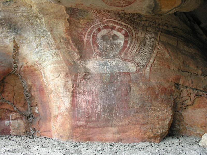
Wandjina Petroglyphs Representing Aliens 5000 years ago


It's always been a mystery, although many do speculate, that aliens walk among us. Some have left their mark by using crop circles to communicate a message to us and others have had direct contact with other civilizations.

The Wandjina Petroglyphs are a perfect example of this. It's odd really. Today we tend to describe these extra terrestials in the way of small heads, a flat mouth, and no nose. However, according to Aboriginal mythology, if these creatures were seen with no mouths, the rain would never end.

Wandjinas are believed to have made the sea, the earth and all its inhabitants.The existing rock art found, has depicted them as having huge upper bodies and large heads. Their faces show eyes and nose, but typically lack mouths. Around the heads of Wandjinas there appears to be lightning and feathers. The Wandjina is thought to have special powers and if offended, can cause flooding and
intense lightning. The paintings are still believed to have special powers and
therefore are to be approached cautiously.

Wanjina Rock Art


Source

Also check out:

Mysterious Crop Circles

Friday, July 31, 2009

Largest Cave Ever Found in Vietnam


The largest single cave "Son Doong" was just found in the Vietnamese jungle measuring close to 120 x 120 meters in some areas. Explorers can walk close to 3 miles before being stopped by the flooding water.

The team that explored the cave found an underwater river system along with the usual stalagmites associated with limestone caves.

"The terrain in that area of Vietnam is very difficult," said expedition team member Spillane.

"The cave is very far out of the way. It's totally covered in jungle, and you can't see anything on Google Earth," he added, referring to the free 3-D globe software. Read the Full Story of Son Doong cave on National Geographic


Screenshot by Author: Photograph by BARM/Fame Pictures

See more photo's of the cave

Friday, July 24, 2009

Photomicrographs and Macro Photos of the Most Astounding Igneous Rocks


What is an Igneous Rock?

Most rocks are aggregates of crystals or grains of one or more minerals. The minerals that make up the structure of an igneous rock can be quite small, although they are still able to be identified.

Ever since the beginning of the Earth, rocks have been the eyes and ears of evolution. Their experiences have been solidly held in a tight capsule, only to be later examined by geologists and researchers. Read More about Igneous Rocks

Monday, June 15, 2009

Six Notable Archaeological Forgeries in History


This post has been removed as the story was linked to a site that is no longer online. I apologize for the inconvenience.

Check out Archaeology.org's extensive list of Hoaxes, Forgeries, Fakes, and Strange Sites:

Archaeology's Hoaxes, Fakes, and Strange Sites


Wednesday, June 10, 2009

Photography of Utah: Somewhere in the Canyons


Believe it or not, I took these photo's when I was 12 years old. If I had known then what I know now, I would have appreciated them much more.

These photo's are from an old black Kodak camera that I used when I was a kid. I don't think digital camera's were even out yet when I was a kid. In fact, I think the coolest camera to have back then was a Polaroid. You know, the ones that give instant gratification. lol

Sorry for the blur. These pictures are close to 20 years old. Man I'm getting old.

Salt Lake City Utah

Thursday, May 14, 2009

930


Incomplete posts are currently being deleted due to site updates. Sorry for the inconvenience.

Friday, April 24, 2009

Five End of the World Scenarios


Several years ago I was sitting in my Geology class and my professor was telling a tale of the world’s end. The basic scenarios consisted of a large tidal wave swallowing Florida; the earth bursting into flames; and polarity reversal which would leave the earth open to solar flares. Well, none of these stories were making me feel any better, but the truth it, these stories do exist, and predictions for these events exist as well. Are they true? I believe the stories exist to give scientists a answer for certain environmental events that have occurred and need some sort of explanation.

Nostradamus

One of the most famous individuals in history to predict these happenings was Nostradamus. Nostradamus was said to decode the Bible, introducing prophecies that have outlined major world events, including the end of the world. He would use trance and meditation to arrive at certain predictions hidden in the words of the Bible.

predictions made by Nostradamus about the Bible

However, since historians believe that the Bible is 6000 years old, and NASA and Astrophysicists date the earth to billions of years old, I hardly believe that the predictions made by Nostradamus about the Bible could be completely true.

Compass

Knowing

earth on fire

thebadastronomer

The latest blockbuster natural disaster movie called “Knowing” is about solar flares that will penetrate the earth, destroying every life form in existence, except for the children that are transported to another planet by aliens that warned earthlings 50 years prior through a telepathic child named Ursala. Well, at least the solar flares are true.

Global Warming

global warming

Global Warming

Global warming is the same sort of scenario, yet humans are only 10% of the problem and what’s been done can not be changed. The glaciers, ice burgs, and caps will melt, and the depth of the ocean will rise causing flooding worldwide. In this event, will humans be able to survive an even warmer world?

Polarity Reversal

Polarity Reversal

Polarity Reversal

Every 200,000 years, the earth goes through a shift of polarity. If you pick up a compass at the time that this is happening, it will no longer point North. The idea behind this is, the magnetic shield around the earth is weakening when polarity reversal is taking place, leaving us open to the harsh solar winds and other strong atmospheric pressure and particles from space.

Mega Wave

Mega Wave

Mega Wave

Geologists have been studying models of previous eruptions and have come to an alarming discovery. If part of the mass structure of the volcano slides into the ocean, it will create a Mega-tsunami close to 900 m. high, moving 500 miles an hour, and measuring 1000 ft waves.

A Massive Meteor

Massive Meteor

Massive Meteor

This scenario is of no surprise considering it came from previous historical events of dinosaur extinction. People believe that it’s the will of the earth to start over, wiping out all species to create a new life form that will inherit the earth. It sounds bizarre I know, but if you follow the history of the earth, which is dated over 2 billion years old, you will see that catastrophic events have reshaped the planet overtime.

And so the theories of the end will remain unanswered, but one thing is certain. Life has evolved over time, and if it is the will of the earth to start over, there will be no way to stop it.

Like Ancient Digger? Why Not Follow Us?


Subscribe Via RSS Feed Follow Ancient Digger on Facebook Follow Ancient Digger on Twitter Subscribe to Ancient Digger Via Email

Get widget

Search


Ancient Digger Archaeology Copyright © 2015 LKart Theme is Designed by Lasantha