• Ancient Digger teaches Archaeology and History to all Ages!

Saturday, April 30, 2011

The Anthropology of Hemispheric Localism Pertaining to Latina Gangs


The term “gang-talk is hemispheric localism” describes both Nortenos and Surenos who are territorialized based on their customs of race, language, class, and national identity.

The gang members’ concepts of the mission and purpose of the gang as a social union respond to broader contextual pressures that include a members’ familiarity of Latin migration dynamics and their own gangs’ internationalization, as well as their understandings of worldwide political relations.

Therefore, hemispheric localism refers to, in this particular situation, the “North” and “South” and their “webs of signification”.

Read Gang Talk is Hemispheric Localism @ Factoidz By the Ancient Digger

New Classical Archaeology Podcasts from Indiana Jen


April 30, 2011- Indiana Jen is operated by Jennifer Locket who is a Classical Archaeologist by training and is currently teaching history to bright, young students at Trinity Valley School in Fort Worth, TX.

If you enjoy Classical archaeology as much I do, you'll thoroughly enjoy her podcasts featuring the Roman Empires' first emperor  Augustus who changed the landscape of Rome and furthermore is a model of morality, spreading this message via new laws. Jennifer has also conveniently included the history of Trajan and Hadrian, Ancient Eats, Republican Architecture, among many other Classical topics.

If you have a moment, make sure to check out Indiana Jen. For those of you Classical Archaeology majors and hopefuls, these podcasts are an excellent source for gaining understanding of the Classics.

Thursday, April 28, 2011

Pyramids of Caral in Coastal Peru


In the mist of finals this week, I was assigned a video which documents the discovery and history of the archaeological site of Caral. If you haven't seen it, this is a short synopsis. Caral is located upstream on the coast of Peru.


Situated in the Supe River valley, Caral has a number of large buildings including the temple and circular sunken courts. Most likely there were irrigation canals enabling them to farm the arid lands around the river.


"The inhabitants of Caral, despite living many miles from the ocean, ate an enormous amount of sea food in their diet. They probably traded their agricultural crops for the marine resources obtained by people living in coastal towns and villages. Despite the large buildings and evidence for long-distance exchange in the Preceramic, there are no tombs or even elaborate houses".~Dr. Barber


Caral is unique in that is disproves Carneiro's warfare theory. In fact, no evidence has ever been found indicating warfare sparked the emergence of social complexity at this archaeologysite.


Watch this series about Caral as I'm sure you'll enjoy it as much I did.


Monday, April 25, 2011

Weapons Used During the Civil War


The middle of the nineteenth century was a time of great change in America. The industrial revolution was in full swing, especially in the North. This brought about rapid change in both manufacturing capacity and in technological development. This would be put to deadly use during the American Civil War, where advances in Civil War guns and cannons would revolutionize centuries-old military tactics. The weapons used during the Civil War were far more accurate than previous weapons and old strategies would lead to countless casualties as generals slowly and painfully learned new ways of fighting in a world of industrial warfare and Civil War weapons.

Smoothbore Musket


Prior to the Civil War, the standard weapon of choice for infantrymen was the smoothbore musket. These guns would fire round balls out of barrels without any grooves inside of them. Due to their design, muskets were generally only accurate for short ranges. This characteristic determined military strategy for the time period, where infantry units were grouped together for maximum firepower. To do this, battles were often fought over open ground in columns. This in turn influenced the development of both artillery and cavalry tactics. For instance, cavalry units could only effectively maneuver over open ground, where they could use their superior speed to overtake enemy positions. And since smoothbore muskets were generally inaccurate at long ranges, cavalrymen could charge without the threat of such fire.

Minie Ball


But the development of a new type of Civil War gun and ammunition, rifled guns and the Minie Ball, changed the weapons used in the Civil War. With this new Civil War gun, bullets would rotate has they moved through the air, greatly increasing their accuracy. Now, infantrymen were far more accurate with their shots, greatly increasing their effectiveness.

CW Arty Confederate Napoleon

Unfortunately for many of the soldiers at the time, military tactics were still in use based on the assumption of the old, smoothbore muskets and not the new weapons used during the Civil War. With these new Civil War weapons, there was a much greater value for defensive fortifications. Charging a defended position over open ground was essentially a suicide mission, especially if the other side was further protected by cannons. Perhaps most importantly, cavalry units became a lot less useful in this new military world. And as the war progressed, generals slowly but surely began to use their cavalry more for reconnaissance and supply duty than for actual battles.

Civil War Last Photo Of General Robert E Lee Portrait Picture Art PrintBut it was a slow and painful process to adapt to the new weapons used during the Civil War. Time and time again, generals would send their units over open ground to charge entrenched positions with the new Civil War weapons. And the results, predictably, were grim. Perhaps the most notable example of this was Pickett's Charge during the Battle of Gettysburg, where General Robert E. Lee marched his army over a mile of open ground to attack the center of the Union lines. But thanks to those new Civil War weapons, the charge was an epic failure. Indeed, many call that moment the “high tide of the Confederacy” and that the South was never able to fully recover from that tragedy.

Hawkin Rifle


The amazing thing was that this was not the first time General Lee encountered such a situation. During the Seven Days Battle in 1862, the Confederate army was pushing the Union away from the capital of Richmond and towards the James River. Towards the end of the week, the South reached Malvern Hill, where the North had a powerful defensive position in order to protect the flank as they retreated towards the river. General Lee, seeing an opportunity to split the Union army in two, charged across the farm fields into the Union cannons and infantry equipped with a new Civil War gun. They were easily repulsed with much loss of life. Fortunately for Lee, Union General George McClellan did not press the advantage and continued to retreat. But despite this painful loss, General Lee apparently did not learn his lesson when he ordered that famous charge across the fields of southern Pennsylvania. It took him a long time to realize that the new weapons used during the Civil War required a new way of fighting, since these new Civil War weapons were best utilized in different capacities.


As the two sides slowly came to realize how unsuitable the old tactics were with the new weapons used during the Civil War, trench warfare became the standard tactic for protection from the enemy. Combined with the new Civil War weapons and cannons, frontal assaults became even more deadly. But by 1864, the Union was now led by General c. He was determined to use the North's numerical superiority to overwhelm the armies of Lee. And thus he continually attacked well-entrenched Confederate positions using the modern Civil War gun. He did achieve his goal of keeping the pressure on the South, but only at a tragic cost in lives lost. Perhaps the most devastating of these moments was at the battle of Cold Harbor, where an early morning assault on the morning of June 3 led to 7,000 Union casualties in less than a half-hour of fighting.

Napoleon 12-Pound gun

Napoleon 12-Pound gun
(In 1853, France introduced the Canon-obusier de 12, a 12-pounder capable of using either shells, shot or canisters. Napoleon cannon remained in service during the Victorian period seeing action in the American Civil War)

These casualties were further multiplied by the extensive use of cannons during the war. Although advances with cannons were not as far along as they were with the new Civil War gun, they were still extremely effective in countering frontal charges. Unlike the Civil War gun, most cannons used in the Civil War were still smoothbores, not rifled. The most popular of the Civil War artillery was definitely the Napoleon 12-Pound gun, named for the famous French general. These cannons could fire a variety of ammunition, depending upon the situation. Solid shot was a typical ammunition used to batter advancing enemy columns. Cannon shells, on the other hand, were exploding ordinance that was particularly effective against fortified units. But perhaps the most devastating of all artillery ammunition was the canister shot. This type of shell contained hundreds of miniature balls inside of it and could absolutely mow down advancing infantry units at close range. Artillery firing canister shells stopped many infantry charges during the Civil War.

There is no doubt that the weapons used during the Civil War, including the new Civil War gun and other Civil War weapons, led to a far more deadly type of warfare and a complete reevaluation of military tactics. The ultimate consequences was a civil war with 600,000 casualties and a country nearly torn apart in the process.

Thursday, April 21, 2011

Rome: Romulus and Remus Story


One of the most famous stories of Rome, the history of Romulus and Remus continues to captivate to this day. The history of Romulus and Remus tells the story of how Rome was first founded, and modern archaeology provides tantalizing clues to the legend of these brothers as well.


The story begins in the city of Alba Longa. The Romulus and Remus legend contends that they were the twin grandsons of Numitor, rightful king of the land. The twins appear to be divinely conceived, with a human priestess mother and the god Mars. The history of Romulus and Remus begins with strife, when Numitor’s brother Amulius disposed of him and left the twins to die in the Tiber River as infants. The fates were on the side of the twins, and they survived due to one miracle after another. Instead of drowning, a she-wolf discovered the twins and nursed them as infants, along with the help of a woodpecker that would bring the babes food. Then, they came under the care of a kindly shepherd and his wife, who raised them to adulthood. By another incredible twist of fate, they ultimately ended up being brought face to face with Amulius and were told of their real identities. As natural leaders, the brothers were able to amass a strong following and dispose of Amulius, restoring their grandfather, Numitor to the throne. With their grandfather at his rightful place on the throne, the brothers then decided to found a city of their own.

SHE WOLF nursing her Twins: REMUS and ROMULUS. Roman Commemorative 330 AD.
When faced with the task of locating the site of their city, the brothers were conflicted. Romulus was in favor of building their city on Palatine Hill, but Remus favored Aventine Hill. They decided it would be up to the gods to decide the location of the city and began to look for divine signs. According to the history of Romulus and Remus, each brother saw signs in the form of birds. While Romulus saw more birds than Remus, Remus contended that he saw his first and therefore was in the right. Eventually, work began on the site that Romulus selected, while disputes between the brothers continued to grow. Eventually, these disputes led to brother turning on brother. According to the Romulus and Remus legend, Romulus murdered Remus after his brother mocked a wall that he had built on the site. The city was then named Roma after Romulus and he went on to create the Roman Senate and Roman legions.

Archaeologists and scholars often see the Romulus and Remus legend as an analogy for Roman citizens and the history of the city itself. Although there is little doubt that the city itself garnered its name from Romulus, there is great speculation about his brother Remus and the circumstances of his death. In addition, there is great speculation about whether or not the brothers actually did exist. Scholars commonly accept that the brothers were a myth themselves, and that the city gained its name from the fictional character of Romulus, and the evidence presented by archaeology lends credence to this belief.

For modern visitors, Rome offers up tantalizing archaeology, which hints at the history of Romulus and Remus. Symbolism showing a she-wolf with two infant children abounds throughout Rome. Pliny the Elder even described a statue of the she-wolf that once stood in the Roman Forum. A bronze statue that closely represents the original is on display in the Capitol Museum. Although this statue has been dated to the middle ages and not the antiquities, it is still fascinating to gaze upon a modern reminder of Romulus and Remus legend.

Ancient Rome: The Archaeology of the Eternal City (Monograph, 54)Another recent find in Roman archaeology is commonly recognized as a memorial to the Romulus and Remus legend. Located under Palatine Hill, the site discovered in 2005 has yielded rich finds pointing to the location serving as a memorial dedicated to the brothers during the Roman age. Among the artifacts found were painted seashells, pumice stones and even mosaics. Archaeologists working on a renovation project centered on Emperor Augustus’ palace discovered the cave, which has been closely tied to the Romulus and Remus legend.

Other finds in Modern archaeology have heralded other tantalizing glimpses that support the Romulus and Remus legend as well. In 1988, a wall dating back to the appropriate period was unearthed, fitting nicely into the history of Romulus and Remus. At least one modern archaeologist has even gone so far as to claim it is the very wall depicted in the history of Romulus and Remus.


The history of the city of Rome is closely entwined with the history of Rolumus and Remus. The story of the rise of Rome seems to echo the themes found in the history of Rolumus and Remus, and modern archaeology has found clues that ancient Romans embraced these brothers as their city founders, regardless of fact or fiction.

In addition to these finds by modern archaeology, the theme of Rolumus and Remus has appeared in many different forms of Roman art. From mosaics to coins, the imagery of twin boys being nursed by a wolf has appeared in a vast array of mediums.

The history of Romulus and Remus may be only a legend, but it has been woven into the deep fabric of Roman history and provides an interesting tale to demonstrate the origin of this majestic city.

Wednesday, April 20, 2011

World's Most Popular Archaeology Museums


Many people are just not satisfied by a photo of historical, natural or artistic items, which is why they visit museums. For those with a strong interest in history and unearthing it, there is nothing quite like the experience of archaeology museums. These museums focus on the field, including archaeological exhibits as a regular part of their offering to the public. Traveling to archaeology museums around the world may not be the easiest task, but the most popular of these museums offer extensive or unique collections, well worth your time.

The National Archaeological Museum of Naples


The National Archaeological Museum of Naples in Italy has one of the world's top archaeological exhibits of Greek and Roman antiquities, particularly those from nearby Pompeii and Herculaneum. Some of the exhibit's features include mosaics, sculptures, glass and silver.

At the museum in Naples, a visitor could expect to see a number of items from or about the historic city of Pompeii that was destroyed by the eruption of Vesuvius in 79 A.D. Among these are the Temple of Isis, which is a special exhibit that includes wall paintings removed from the temple as well as artifacts from it, and a Pompeii model that was created in the 19th century to give an accurate representation of what the city would have looked like prior to the eruption. Additionally, there is a section called the "Secret Cabinet," which contains erotic and sexual items that through archaeology were discovered and preserved, but for some time, such items were deemed inappropriate for the public to view. The "cabinet" was re-opened in 2000, though visitors must be at least 11 years old.

Istanbul Archaeology Museums


The Istanbul Archaeology Museums in Turkey feature a wide array of tools and artifacts through the region's history. The museums' archaeological exhibits include the Kadesh Peace Treaty -- dating to 1258 B.C. and considered the oldest peace treaty in the world -- that was signed between Ramesses II of Egypt and Hattusili III of the Hittite Empire, and the Alexander Sarcophagus, a late fourth century B.C. stone sarcophagus adorned with bas-relief carving of Alexander the Great.

Traveling to archaeology museums around the world, it is uncommon to find one that technically includes three interconnecting museums. The Istanbul Archaeology Museums consists of the Archaeological Museum, the Museum of the Ancient Orient and the Museum of Islamic Art. Together, they house over one million objects that represent nearly all eras and civilization in recorded history.

Peabody Museum of Archaeology and Ethnology


The Peabody Museum of Archaeology and Ethnology in Cambridge, Mass., is one of the oldest museums in the world devoted to anthropology. Affiliated with Harvard University, the museum contains one of the most comprehensive collections of human cultural history in the Western Hemisphere. The museum's archeological exhibits focus on the native people of North America as well as displaying casts from Mesoamerican monuments and objects from the Pacific Islands.

Though some of the museum's artifacts are permanent fixtures, like the Louis and Clark and Hemingway collections, others are part of a rotating schedule of exhibitions. Without traveling to archaeology museums throughout the Americas, a visitor to the Peabody has the opportunity to see one of the largest and most extensive collections of indigenous people of North America and Mesoamerica. Additionally, because of the museum's close connection with Harvard, the collections at Peabody are available for teaching, publication and artistic purposes. Given notice, the museum may grant approval for limited access.

Qin Shi Huang Terracotta Warriors and Horses Museum


Though this may not fit into the same definition with other archaeology museums, the Qin Shi Huang Terracotta Warriors and Horses Museum, which features the now-famous Terracotta Warriors depicting the armies of Qin Shi Huang, the first emperor of China, is a unique type of archaeological museum in its own right. The museum, rather than focusing on numerous archaeological exhibits, centers on the warriors. As the figures remain in the trenches where they were first found by a farmer in 1974, the museum in Shaanxi Province, Xi'an City, Lingtong County, Qinling Town gives the feel of an archaeological dig still in progress.

Devoted to the figures that date from 210 B.C., the pits once held more than 8,000 soldiers, 130 chariots with 520 horses and 150 cavalry horses. Traveling to archaeology museums like Qin Shi Huang can be difficult, which is why a small number of the warriors and a number of artifacts discovered in the area tour countries around the world, giving those of us who have difficulty traveling to archaeology museums in other countries the opportunity to view the life-size figures that guarded the emperor's tomb.

Penn Museum


Penn Museum (The University of Pennsylvania Museum of Archaeology and Anthropology) in Philadelphia, Pa., features a variety of exhibits from cultures around the world. A site ideal for those with trouble traveling to archaeology museums in all the countries they may like to explore, long-term archaeological exhibits at Penn Museum include features on Africa, Egypt, Buddhism, Islam and ancient Greece and Rome.

One of the prominent archaeological exhibits at the museum features more than 100 ancient artifacts from the Amarna period in Egypt and the time of Tutenkhamun, some of which have never before been on display. For this ancient culture, this period was a time of religious and cultural experimentation. Another long-standing exhibit contains nearly 25,000 artifacts from excavations in the Levant, which includes areas in modern Israel, the West Bank, Jordan and Lebanon. The collection is the largest from the region in any of the museums in the United States and Western Hemisphere.

The National Archaeological Museum in Athens


The National Archaeological Museum in Athens includes artifacts from a variety of locations in Greece important to archaeology, such as Santorini, Mycenae, the Aegean islands, Delos and the Sanctuary of Artemis Orthia in Sparta. The collection of artifacts from Greek antiquity is considered the richest such collection in archaeology museums worldwide.

Among the 11,000 archaeological exhibits at the museum is the wrongly-named Mask of Agamemnon, one of the most famous pieces in the collection. The museum encompasses sculpture, metalworks and pottery, among other collections, from the archaic period through classical Greece and the Hellenistic era. Like a number of other museums, it does not focus just on the culture of its own country, but has collections of Egyptian and Cypriotic antiquities that were presented to the museum from various donors.

The Petrie Museum of Egyptian Archaeology

Living Images: Egyptian Funerary Portraits in the Petrie Museum (UNIV COL LONDON INST ARCH PUB)

Located in London, U.K., the Petrie Museum of Egyptian Archaeology has an estimated 80,000 objects, making up one of the largest collections of Egyptian and Sudanese items in archaeology museums worldwide. It may come as a surprise when traveling to archaeology museums that such a large number of Egyptian artifacts are housed in London, but much of the Petrie Museum's collection comes from documented excavations.

Among this extensive collection are one of the earliest pieces of linen from Egypt, two lions from the temple of Min at Koptos and the earliest example of glazing. Much of the collection consists of firsts, or at least earliest, archaeological finds of their kind.


Kelsey Museum


If your a Classic's buff or love the lives of the ancients like I do, the Kelsey Museum in Ann Arbor, Michigan is a trip you just can't miss. Kelsey Museum "houses a collection of nearly 100,000 ancient and medieval objects from the civilizations of the Mediterranean and the Near East in the William E. Upjohn Exhibit Wing. Aside from the permanent collection, new exhibits are presented on a regular basis at Kelsey.

I'm a bit partial to the seal artifacts found in Iran, such as the Stamp Seal showing Ibex from Tepe Giyan, Iran. Kelsey has an amazing collection of these which I've only begun to investigate.

 Visitors are always welcomed if you'd like to check out their visitor information page for more details.

Picture Sources
© Istanbul Archaeological Museums
© UPENN 
© Kelsey Museum

Tuesday, April 19, 2011

Archaeology News: The Extinction of The Gazelles Caused By Ancient Hunts


APRIL 19, 2011--About 5,000 years ago in the Middle East, hunters drove a species of gazelle to the edge of extinction by funneling entire herds into carefully constructed stone corrals, where the animals were easy prey.

That’s the theory of Smithsonian Institution archaeologist Melinda Zeder and two of her colleagues, who report stunning evidence of such a mass kill in modern-day Syria.

“It must have been one heck of a barbeque,” Zeder said. “The scale of it is really quite staggering.”

The people living in the Middle East 5,000 years ago subsisted on goats and sheep while developing early architecture.

But every spring, herds of Persian gazelle thundered from breeding grounds in the south, near the Arabian peninsula, to the lush green steppe in the north, where the animals gave birth. In August, the herds roared back south.

Ancient hunts drove gazelle toward extinction @ Washington Post

Tucume: Las Pirámides del adobe que Son anteriores a los incas


Author note: Back in February, I had mentioned Tucume in passing, linking to an archived article of mine about this illustrious ghost town. This is the piece in its entirety.

The Lambeyeque Valley in Peru is the site of six adobe pyramids, known by the Lambeyeque people, as well as the Chimu tribe, as the sacred site of Tucume.


Source

The adobe pyramids were constructed before the arrival of the Incas around 1000 to 1100 AD and they are legend to be haunted by evil spirits. The indigenous people are enamored by the site, refusing to visit, afraid of what harm might come to them. It's no wonder that Tucume has been given the name "purgatoria", however many suspect the name was given by the Spanish Conquistadors to stop people from visiting the site. Oddly, grave robbers have never attempted to loot Tucume because of its alluring reputation.

The civilization thrived raising crops and animals and formulating a complete info structure including waterways and manmade watercourses.

Tucume - Sican culture ca 1100AD then Chimu - Spanish used to throw people to their death

The most recent discovery of 119 bodies suggests that ritual sacrifices were performed in one of the many temples on site. Consequently, the sacrifices were most likely performed by the Incas in an attempt to stop Spanish Invasion in 1532.

After the arrival of the Spanish, the only thing that remained of Tucume was the adobe pyramids. Sadly, after Peru was conquered by the Spanish, Tucume was abandoned and exists only as a ghost town.

Tucume was little known to the world until 1988 when Thor Heyerdahl, a Norwegian explorer, embarked on several excavations. His discoveries led to increased interest about the site. Among his discoveries were Incan and Chimu textiles, metalwork, and pottery. In addition, 40 tombs and burial sites were unearthed, including one such tomb that included "a prominent Inca general, possibly the governor of Tucume".

The entire site spans over 540 acres and includes 26 major pyramids and mounds. The largest of the pyramids is the Huaca Larga, measuring 700 meters in length, 280 meters in width, and 30 meters in height.

Today, the site remains a ghost town, with the exception of a few travelers passing by to take pictures or bike.

Monday, April 18, 2011

Monday Ground Up: The Role of Aerial Imagery in Archaeology


Guest article by John Carter

Long before Google Earth ever became a fixture on the Internet we’ve had aerial photos. In fact, the first aerial photo in the world was taken from a balloon of Boston Harbor in Massachusetts by James Wallace Black on October 13, 1860. There had been earlier attempts at aerial photography in Paris, France, but these were taken from a kite. From these humble beginnings, the use of aerial photography spread to many other disciplines including archaeology, but its main early use was in warfare. Extensive use was made of aerial photos taken from balloons during the American Civil War.

first aerial photograph used in archeology
(This is the first aerial photograph used in archeology. The site is Stonehenge in the United Kingdom. There have been many advances in aerial photography used in archeology since; one of them is Google Earth a powerful tool. This photo was taken by Lt. P.H. Sharpe from a balloon in 1906.)

The first aerial photos of an archaeology site were a set of photographs of both oblique and vertical taken by Lieutenant P.H. Sharpe in 1906 of the famous megaliths at Stonehenge. Between 1908 an 1911 a group of Italian engineers photographed the Forum Romanum along with the harbor works at Ostia. In 1912 a group of Italian archaeologists photographed a site that was thought to be a Roman fort from the air using a balloon. However later excavations proved this site was a Roman villa not a fort as first believed.

The first big improvement for aerial photos came about because of WWI.  World War I introduced the idea of dedicated aerial cameras to the field. During WWII further advancements in aerial photography were introduced including the use of color film. The growth of aerial photography touched off a revolution in the use of the full magnetic spectrum in what is now called “remote sensing.” If the whole magnetic spectrum were to run through a pipe it would have the diameter of the Earth, but the visible spectrum that we can see with our eyes would only have the diameter of a pencil. It is the unseen portions of the magnetic spectrum that are taken advantage of in remote sensing.

castle at Malden Hill, Somerset
(This is the castle at Malden Hill, Somerset an aerial photo of an Iron Age hill fort that was taken by the English Heritage Foundation. This is a good example of how aerial images are used in archeology.)

There are many uses for remote sensing across the broad spectrum of the disciplines that are used by mankind, archaeology being only one of them, but for the purposes of this paper we will only consider those that apply to archaeology within the visible spectrum, and specifically Google Earth and its close relatives.

Google Earth For DummiesA preliminary version of Google Earth was launched in April 2005 with Google Maps including satellite views, and Google Earth was finally launched as a free standing member of the Google family in June of the same year. There are similar products available from Teraserver and Flashearth and a whole collection of aerial imagery from the United States Geological Survey (USGS) that are all useful in archaeological studies.

Because of copyright constraints on Google Earth you must look up the sites on Google Earth yourself, but we will give you the geographic coordinates that appear at the bottom of the screen. This is one of the most useful of the many features of the program. As we understand these coordinates are accurate to 8 inches and can be used with a hand held Global Positioning device. Another useful feature of Google Earth is the ability to zoom in or out on your site of interest.

I recently wrote an article titled the First Mountain Railroad in the World  where I used Google Earth to trace the route of the Boston & Albany across the Berkshires from Chester to Pittsfield, Massachusetts allowing me to accurately trace the twists and turns of this railroad that was built in the 1840s. The coordinates for Chester, MA are: 42­­o 16’ 45.22” N 72o 58’ 43.18” W.

Great Pyramid of Chephren at Great Pyramids of Giza, Cairo, Egypt Photographic Poster Print by Cindy Miller Hopkins, 36x48Integrating Google Earth allows you to examine existing archaeological sites in full color like the Great Pyramids at Giza in Egypt. The Great Pyramid of Cheops can be seen at: 29o 58’ 33.74” N 31o 07’ 50.67” E that puts the cursor right at the pyramid’s pinnacle. By observing the shadows on the pyramid you can even determine the time of day the photo was taken. In this case the shadows indicate the exposure was made at about noon on the first day of summer. The shaded area is on the north face of the pyramid. The small blue squares are of the different photos of the site that have been uploaded. See if you can find the Sphinx in these aerial photographs, it is there.

Rome is an archaeologist’s paradise because there are so many archaeological treasures to be seen. Two of them are Capitoline Hill located at: 41o 53’ 34.22” N 12o 28’ 59.93 E and the Colosseum at: 51o 53’ 22.77 N 12o 29’ 30.29” W.

Google Earth has many features that are useful in archaeology along with other disciplines, the first of which is the ability to look down upon a site from above giving us the ability to see things that are not often seen from the ground. Among these many things are both present and future archaeological sites. Many of these sites are at present unknown, but by the use of aerial imagery they become apparent. There are many clues visible from the air causing these sites to stand out from the background. It is possible to make out the traces of old foundations or roads where future archaeological digs could take place. Some of the most obvious signs are stressed vegetation or sudden changes in the ground cover that are almost always sites requiring further examination.

It is not the purpose of this article to queue a full explanation of the things that are possible with Google Earth or photo interpretation, rather this article is intended to only act as an introduction to the subject. A great deal has been written on the subject already, and there are even associations that cover the discipline for those who are interested. One of these societies is the American Society of Photogrammetry and Remote Sensing (ASPRS),  where you can learn a great deal about the subject of not only aerial images, but also the field of remote sensing.

Author Bio

John Carter is a geologist that paid his way through college as a commercial helicopter pilot in the NY Metro area. He has had extensive experience as a prospector, and operated an environmental consulting firm specializing in environmental site assessments and is certified by the State of Connecticut as an Environmental Analyst III. In his early life he worked as an experimental machinist on aircraft and electronic parts before receiving his degree as a geologist.

Saturday, April 16, 2011

Was There A Real Indiana Jones?


Otto Rahn Nazi Archaeologist is the real Indiana JonesThe results are in ladies and gentlemen and I’m not at all surprised that many of you said “yes”, there was an Indiana Jones. The problem with this answer is that many people can’t agree on who it actually was.

The film character “Indiana Jones” played by Harrison Ford was actually based off of the Nazi archaeologist Otto Rahn, whom Spielberg based his movies on. Otto was a bizarre chap, and if you’d like to learn more about Otto Rahn, the Telegraph did a great piece on him.

Unicorn Man at Ripley's Believe It or NotAnother rumored Indiana Jones was Robert Ripley, from “Ripley's Believe It or Not!”

Robert was an eccentric and avid traveler. He took the world by storm visiting far off lands and unblemished territories and cultures. Places like India and the Orient were unconventional areas for the American traveler during the 19th century, however Ripley's obsession drove him to these areas to study the local customs and speak with people in the area. In total, Ripley traveled to over 201 countries. Yet, my only question with Ripley is that he represents more of an anthropologist collecting ethnographies, however he did come back with some pretty bizarre finds, including the shrunken head.

Howard CarterThe famous Howard Carter who had worked in Egypt since the age of 17 was an adventure seeker. Even though he was warned against entering the Tomb of King Tut he went forward with his excavations anyway and made one of the most famous and infamous discoveries in Egyptian archaeological history. With his charm and wit and drive to conquer the sands of time, many believe he was the true Indiana Jones.

So the answer to the question, “Was there really an Indiana Jones?” is actually yes, there were many.

You’re turn. Let me know who you think it should be, or is, in the comments area.

© Gnostic Liberation Front (Otto Rahn) © Ancient Digger (Unicorn Man)

Copan Ruins In Honduras


The settlement at Copan is located not far from the borders of Honduras and Guatemala and is believed to exhibit the some of the most amazing ruins of the Mayan occupied territories. Copan achieved its greatest standing during the 5th century under the ruler the Great Lord Quetzal Macaw. The Great Lord was named after two of the most prominent birds in the area and he left a legacy of a settlement that thrived until the 12th century.

What distinguishes Copan from the other pre-Columbian ruins is that the people were not forced to leave by the Spanish. In fact, they appear to have moved before their arrival, at least two years prior to the conquistadors.


There are several theories as to why they left the civilization at Copan, however the most widely accepted belief is that they left because the land was no longer suitable for agriculture.
As for the name, no one really knows if the original settlement had one. However, during the 16th century, the Spanish decided to name it Copan.

Replica of Rosalila Temple 

Rosalila temple replica
© xinning

If you happen to travel to the site, it takes several days to walk around the ruins. There are numerous royal homes, servants quarters, religious areas, and middle class dwellings around the site. There is, however, something that lies beneath, buried by the Maya and incredibly well preserved. Under the ground lies the 6th century Rosalila Temple, with the original layers of intricate paint and design.


Source

Like many other pre-Columbian civilizations, there are temples above the ground decorated with carved human faces. The faces are both frightening and humorous, some also taking the form of animals and birds.

Today, the macaws of Copan still inhabitat the ruins, flying around the ancient temples and ruined buildings. Sadly, however, the quetzal is rarely seen due to its endangered status.

Picture source Temple © pirate0007


Thursday, April 14, 2011

The Environmental Site Assessment as an Archeological Study


Guest article by John Carter

An environmental site assessment (ESA) is a report mandated by law designed to establish the well being of any piece of property that in practice usually applies to commercial and/or industrial properties. An ESA is divided into three parts called phases that are numbered I, II and III. A Phase I report is used to determine whether or not the possibility of a release of hazardous material has in fact occurred on a property by determining its prior history. A Phase II report determines if in fact that a release has occurred on a property by taking samples from the property and subjecting them to a battery of lab tests. If in fact the results of this analysis returns indicating that there are indeed hazardous materials that are found on the property above the threshold levels mandated by law the property has to undergo a Phase III Investigation to determine the amount, extent and the effects on human and other life forms the contamination will cause. Photocopies are taken of each report for inclusion in appendix A. of the ESA, and a brief annotation is included in the finished assessment.


023_003 Industrial Park in Manchester
(This is an aerial photo of an industrial park in Manchester, CT showing several areas of environmental interest.  Try locating them on the photo, describe why they would be on interest, and try to determine which ones would become archeological sites in the future?)

Together the three phases of an ESA are very similar to an archeological study, but the single phase that develops the most information that pertains to a specific piece of property is Phase I. This part of an ESA starts in the reading room of the government body of the state that has charge of environmental affairs. This is a collection of environmental records that report any releases of hazardous materials that are known to have occurred on the property or that have occurred off the property, but could have compromised its environmental integrity.

The next stop is usually the state library where they keep other forms of documentation required for a site assessment like aerial photographs, insurance maps, city directories, telephone books and town histories. Even more information can be gathered from back issues of newspapers. Copies of all this documentation are included in Appendix B. of the ESA. As you gather this material you are also writing part of the ESA.

There is also a considerable amount of other information that has to be gathered from the town records of the town where the property is located among them are: Land Records dating back to 1940, or earlier if necessary. We once had to trace the land records back to 1763 because then the property in question had been the largest tannery in the state. Tanneries are one of the most environmentally damaging establishments there are; they can be a nightmare especially if they ever used the Chrome Tanning Process leaving behind a trail of Hexavalent Chromium contamination.

The local search continues with records from the Fire Marshall, the Planning and Zoning Commission, a search in the morgue of the local newspaper and finally statements that are taken from some of the locals who have had contact with the site. There is some additional material like a description of the process if any that has been manufactured or used on the site.

A Phase I ESA is written up and ends with a set of conclusions that affect the outcome of the ESA either it ends with the conclusion that no further environmental work needs be done. If there is historical evidence that the probability of a release occurring on the property is high then the nature of the release and its location is included in the conclusions, and the recommendation is that further environmental work is required so that the ESA continues with a Phase II investigation.

A Phase II ESA is designed to determine if in fact a release of hazardous materials did in fact occur on the property. Although this report is much shorter it deals strictly with the chemical analysis of air, water and soil samples from the site and sometimes “wipe samples” that are taken inside of any structures that are on the property that have been listed as suspect during the Phase I ESA. The various samples are taken at the site according to American Society of Testing Materials (ASTM) standards and transported under a Chain of Custody (CofC) to a certified analytical lab for analyses.

A similar report is drawn up to the Phase I only this time it describes the results of the analysis and reports on the allowable Environmental Protection Agency (EPA) guidelines for hazardous materials. The EPA has a table of the various contaminants of concern. If in the course of analyses any of these standards are exceeded the site is deemed contaminated, and the Environmental Analyst must proceed with a Phase III ESA.

Generally if a property fails a Phase II Investigation the owner or buyer walks away from the property allowing it to become a Superfund or RCRA property. This is the origin of many industrial properties that are designated as “Brownfields.”

A Phase III ESA is similar to a Phase II only it goes into much more detail because it not only tests for contaminants, but also tests for there extent and effects on humans and other life forms.
The similarities between an ESA are uncanny, and the ESA with some modifications could stand as a good plan for designing an archeological dig; all that is needed is to change the objectives. Rather then searching for hazardous waste releases you are hunting for artifacts of a previous age. The ASTM Standard for Phase I ESAs is ASTM 1577-05 and a guide for conducting an ESA is ASTM E1528 that explains the parameters of an ESA, or could be modified to an archeological site.

In truth, there are many similarities between an environmental establishment and an archeological site; the main difference is measured in years, and remember today’s site is tomorrows archeological dig that is performed to discover how people lived in the past. The ESA gives the analyst an insight into industrial archeology, and ultimately many of the same problems exist. Have you ever seen an ancient Superfund Site, they exist.

Author Bio

John Carter is a geologist that paid his way through college as a commercial helicopter pilot in the NY Metro area.  He has had extensive experience as a prospector, and operated an environmental consulting firm specializing in environmental site assessments and is certified by the State of Connecticut as an Environmental Analyst III.  In his early life he worked as an experimental machinist on aircraft and electronic parts before receiving his degree as a geologist.

Wednesday, April 13, 2011

An Unexpected Discovery By A Guy That Looks Like Indiana Jones


Ok, so it's not a real discovery, but it's a parody of sorts (actually an advertisement), and I know how you like those. This one minute short film chronicles an adventure by one so called archaeologist. As he presses on the Ankh, see what happens. You'll never guess!

Veronica Franco and Venetian Courtesans


Guest article by Sarah Moses


Venice, Italy may be known for many things, including its streets of water and its gondolas, but centuries ago, it was also known for its venetian courtesans. These women -- some of whom fit the idea of a prostitute while others were cultured intellectuals -- made up about 10 percent of the number of Venice's population in the middle of the 16th century. The government and social structure of the city during that time was not immune to the influence of Venice courtesans. In fact, courtesans in politics, like Veronica Franco, were not uncommon; edicts from the city's government reflect how importantly these women were viewed by those in power, many of whom could be found on courtesans' rolls.

The history of courtesans in Venice was long-standing; even officials recognized their place within the city's society. This was recognized in an official document from the Italian republic that setting guidelines for women to be considered courtesans: "Any single woman who has intimate connection with one or more men and also any married woman who does not live with her husband but separately and who has intimate connection with one or more men is considered a prostitute."

For much of its existence, the city on the water was known for its independence; to an extent, this was true even from the Roman Catholic Church. It was said during the middle of the 15th century to the 16th century, the high period of Venetian courtesans' profession and the beginning of the church's inquisitions throughout Europe, that inquisitors were more likely to pacify church dignitaries, rather than follow their rules to the letter.

In fact, documents still exist showing that prostitution was believed to help prevent the spread of evil acts or mortal sins, rather than being one itself. One such document shows that prostitution was believed to combat the spread of homosexuality; acts of sodomy could be punishable through torture or death. At the turn of the 16th century, Venetian courtesans who lived in special quarters were ordered to sit at the windows with their legs outsides and breasts naked to be more attractive to men and combat homosexuality.

Additionally, the flow of money, particularly foreign, was viewed as a benefit to Venice's economy.


Classy courtesans


The history of Venetian courtesans is largely affected by how they were divided into classes. Though lower class courtesans (cortigiana di lume) would most closely resemble the idea of a prostitute, it was those of the higher class that were drastically different from these expectations of courtesans in Venice. These women, called cortigiana onesta, "honest courtesans," usually had a life of luxury that was provided by one or a few patrons. These women could be as well-versed and cultured as any upper class lady, in some cases more so.

Some of the "honest" Venetian courtesans wore clothing that was made of such fine materials that they could sometimes be mistaken for upper class women. Tourists sometimes were confused why women in the city wore such fine but low cut clothing that revealed cleavage, sometimes even breasts, not realizing that despite the fine clothing these were courtesans in Venice. These women were not known to avoid attracting attention to themselves, and often encouraged it with their clothing or outlandish behavior.

Despite this, these women were known to be capable of intellectual discussion and had a knowledge of art and literature that could be lacking in many high society women of the time. Since social events were not always abundant, intellectuals in the city would seek an outlet for conversation. These young, educated people often gravitated to courtesans in Venice for this reason.


Veronica Franco


The Honest Courtesan: Veronica Franco, Citizen and Writer in Sixteenth-Century Venice (Women in Culture and Society Series)Veronica Franco (1546 - 1591) was one of the more famous Venetian courtesans. She was the daughter of a cortigiana onesta and was educated by her mother, who sought to see her daughter married well. Veronica Franco did marry a wealthy physician, but she chose to leave her husband when the relationship ended badly. To support herself financially, she began working as an "honest" courtesan to wealthy men.

Her story is not that different from a number of other cortigiana onesta during the 16th century. Many of them, married or single educated women, were seeking a form of financial security through prostitution.

Veronica Franco did not limit herself to being a courtesan, but pursued her own literary interests. She lived well for most of her life and by the 1570s, she was regularly participating in discussions as part of a prestigious literary circle in Venice and contributed to and edited poetry anthologies. She also wrote two volumes of poetry, herself.


Courtesans in Politics


Though courtesans in politics did not have a vote or a governmental title, they had something that most women in Venice did not: the ears of those in power. While no woman could have an official role in the government, "honest" courtesans in Venice were respected for their knowledge on a variety of subjects; when they would talk to their upper class clients, the clients would often listen. Courtesans in politics may not have had a vote, but because of their educated status, their opinions were sometimes taken at a higher value than the wives of those in power. Many married women of the time did not have the broad knowledge and education that the most refined courtesans in Venice had, and their clients knew that.

A cortigiana onesta could easily have patrons who held positions in the city's government, essentially placing these courtesans in politics. In the case of Veronica Franco, they might even have a client who was a king. As a courtesan who catered to the upper class, Veronica Franco had a number of well-to-do clients, the most famous of which was Henry III, King of France. It was said that she presented the king with a portrait of herself. She also included two sonnets to King Henry III in her publication "Lettere familiari a diversi" ("Familiar Letters to Various People").

This did not mean that all courtesans in politics were successful in getting their way with public policy or governmental decisions. Even with the kind of powerful clients that Veronica Franco had, she was not entirely successful when she would make bids for political change. In 1577, she proposed to the city council to establish a home for poor women and that she become administrator of the home, but was unsuccessful in bringing it about.


Luxury, But Not Easy


Venetian courtesans were not immune to the same worries of others within their profession. Sexually transmitted diseases were still a threat, and during the mid-15th century to the mid-16th century, one of the most dangerous was syphilis. Courtesans were among the first victims and were the main spreaders of the disease. There was no predicting what type of clients would prove to be carriers of the disease. Courtesans in Venice could find themselves infected from a doctor or dignitary as easily as an unsavory character. If they became ill, they would almost certainly lose clients and lovers and descend further into poverty and illness.

Venetian courtesans did not only have to worry about the illnesses. The Roman Catholic Church, though it had less of an influence in the city than elsewhere in Italy, still had a presence there. Even Veronica Franco faced a trouble. Though she was cleared of all charges, she faced an inquisition for alleged witchcraft in 1577. This wasn't uncommon for women in the profession during this time.

When compared to their modern or poorer counterparts, it could be surprising to see the roles of courtesans in politics and in literature. These women were sometimes granted more freedom intellectually than their more "respectable" counterparts, which is one of the things that made them so unique for their time.

Biography: Sarah Moses has worked as a reporter and later as a copy editor at a newspaper in western Maryland for the last five years. A graduate of West Virginia University in both Journalism and English, she has always had a great interest and fascination for history.  

Also check out Sarah's article 10 of the Most Notoriously Evil Medieval Torture Weapons @ FriendsRevolution


Pictures
© Venetian Courtesan playing
© Realm of Venus

Monday, April 11, 2011

Monday Ground Up: What Do You Think Were The Best and Worst Aspects of Life In Complex Society?


I was posed this question(Best and Worst Aspects of Life In Complex Society) in a class called Archaeology of Complex Societies. It took me some time to even formulate an opinion as the amount of complex societies is vast, each one complicated in their own way. Each society and their info- structure, social organization, technology, architecture, and access to resources, is like a set of nested tables. One society was built on the next and others rearranged as societies came together because of warfare or environmental pressures.


 Best: Social Equality

Social equality in Mesopotamia complex society for women was virtually equal for both men and women. Women controlled their fertility and marriage was monogamous. If a divorce was sought by husbands and the wife had provided him sons, he forfeited considerable assets and the wife’s dowry was returned. This fact was seen in Knossos as well, as it was remarkably egalitarian between men and women. Women even had social, economic, and political roles as well. In Egypt, although women could not hold government offices, they could handle finances and the household.

In Peru, there was relatively little evidence to suggest social inequality or hierarchy, as people seem to have participated in collective labor without developing strong differences in access to resources.


Best: Infostructure, Trade and Technology

Nothing impresses me more with the planning and development of cities in complex society. Harappan society experienced urban planning, writing, a uniform system of weights and measures, the potter’s wheel, and a waste water system. Mesopotamia had the first writing to serve as record keeping, Cuneiform, Copper metallurgy, Gold, Smelted alloys (copper and tin), and they invented BEER. The Inka had knots for record keeping and taxation (Kepu) and the Maya, hieroglyphics.

As for trade, long-distance trade has been important in the evolution of many states, including those of Mesopotamia and Mesoamerica. Such exchange does develop eventually in all states, but it can follow rather than precede state formation. Mesopotamia and Mesoamerica controlled food production and distribution, which equals power. These societies regulated trade routes in order to suit to own needs, and sometimes, of their people.

In Habuba Kabira, inhabitants were purchasing their food from neighboring cities, thus, Habuba Kabira was mostly inhabited by Sumerians who were not interested in colonizing the territory, but rather using their river access to transport valuable resources south.

In Mesoamerica and Mesopotamia, with the advent of the hydraulic system, the authorities were beginning to control and maintain water as well as personal and group relations. Why is this good? More water=more food=more people. People are able to exploit new environments. In fact, Mesoamerica had “a wide range of resources available from region to region which encouraged exchange among different groups”.


Worst: Social Inequality

In the Dawenkou culture, grave goods painted a considerable picture of inequality as some were filled with jade, tools, ivory, animal bones, and others, were filled with nothing. In the Harappan urban zones, houses with single rooms “crammed together in tenement-like apartment buildings”. However, there were also no palaces in the five large cities that made up Harappan society, so it’s hard to determine the divide in society exactly.

At Teotihuacan, leaders utilized forced resettlement programs after immigrants from surrounding areas and Cuicuilco, populated the large city after the volcanic destruction. Most of the population (extended family) inhabited compounds and nuclear families often took up residence in “smaller sub-patios “in the larger apartment complexes.


Worst: War and Environmental Impact

Archaeological evidence of violence and warfare in Longshan villages turned up burned abodes and burials containing human sacrifices and several scalped individuals. Located between the arms of the Oaxaca Valley were “unoccupied “buffer” zones that archaeologists believe were border areas between competing, and possibly conflicting, political groups”.

At San Jose Mogote a temple was burned, which archaeologically, indicated an elite family was laying claim to the site and used violence to obtain it. At Burial 2 at Teotihuacan, the presence of predators leads many to believe that this offering refers to prowess in warfare. The human sacrifice had hands tied behind their back and was accompanied by a caged puma and wolf. By C.E. 500, temples at Teotihuacan had been burned and looted, possibly the result of a “violent uprising”.


Final Thought

What is evident is that the peoples of complex societies destroyed the environment to support economy via deforestation, soil exhausting, and erosion. We see this in Mesoamerica, China, Olmec, and Cahokia. Consequently, at the site of Catal Huyuk in Turkey, mounds, or “Tells”, rise high above the landscape, and what lies beneath, is thousands of years of garbage and human waste, polluting the earth. Of course, archaeologists view this in another context, calling it stuff or artifacts.

Regardless of impact on the environment, the only way we can examine the past is by looking at people’s garbage, which is representative of cultures across space and through time.

What Do You Think Were The Best and Worst Aspects of Life In Complex Society?

Related Content You May Like


South American Vs Old World Complex Societies: Similarities and Differences

The civilizations of the Old World were in fact derivatives of the first ancient cultures, even dominating their ancient counterparts in Egypt, Mesopotamia, and China. They did so by utilizing new forms of agriculture and technology, improving upon the methods previously noted. The South American societies paralleled the Old World ancient societies in that they exhibited advanced architecture, powerful armies, social hierarchies, and intensive farming systems.


Monday Ground Up: Hunter-Gatherers, Agriculture, and Global Warming

Hunter Gatherers are traditionally described as being highly nomadic individuals that traveled with very  few possessions in a marginal environment. Of course, the factors of the environment directly influenced the ability to be mobile. However, up until the Last Age, we can agree hunter gatherers were highly mobile.

Social Complexity of the Ancients: A Brief Overview

The concept of isolation is among one of the most significant ideas for social complexity, in that all complex societies were never “truly isolated from each other” . If this was the case, all complex societies would or could have, adopted a similar social organization, with the exception of the people living in Shandong Province as the Dawenkou culture, mentioned as having a limited or different access to resources, therefore aiding to a slight variation in organization.

Sunday, April 10, 2011

Dolmens at Shankarpur discovered by Archaeologists


PUNE April 10, 2011: Archaeologists of the Deccan college post-graduate and research institute have found four dolmens of the Megalithic Age (Third century B C) or the Iron Age at the Shankarpur village near Chandrapur, about 150 km from Nagpur. The discovery holds importance as such burial methods are rare in the state and also because one of the dolmens is being claimed to be the largest in the state and India.

Dolmen is an ancient stone structure consisting of a large flat stone on top of two or more upright ones, built above the place where humans were buried. These were usually erected in the memory of the dead.

In India, such structures are mainly found in the southern states of Karnataka and Kerala.

Kanti Pawar led the excavation for Deccan College. He was assisted by students Kim Yong Jun, Akash Srinivas and Pankaj Kahalekar.

Edited from the Times of India: Dolmens at Shankarpur discovered by Archaeologists

Thursday, April 7, 2011

World War I Battleships of the United States


The world’s oceans, seas, rivers, and lakes hold some of war’s most hidden and well kept secrets. From the time the Vikings sailed their small but powerful craft from the fjords of Scandinavia to the mighty aircraft carriers and battleships used during World War I by the United States, boats have helped champion the freedom of nations across the globe. The Spanish Armada and the Queen’s Fleet would bring about change in the depths of the Atlantic by arming their hulls with mortar shattering cannons and crews with muskets. However, one of the largest changes in maritime warfare came with the invention of the large aircraft carriers and WWI battleships equipped with the capability of long distance shelling during the early 1900s.


USS Arizona


USS Arizona MemorialThe USS Arizona would gain its fame early in World War II although it served an important mission World War I naval combat as well. Construction would begin on this Pennsylvania class warship in March of 1913 and would take two years until its completion. The Brooklyn Navy Yard would launch the boat in June of 1915 to begin training missions in and around the East Coast. However, like many other United States battleships, the Arizona would undergo a complete overhaul to be commissioned as one of the naval ships used during World War I. The battleship spent most of its time during the war patrolling the eastern coast from New York south to Florida. Due to the shortage of oil across Europe and most other portions of the world, the oil burning Arizona did not venture into European areas of the Atlantic.
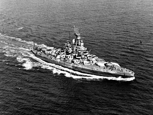

USS Nevada


The "USS Nevada was based out of Scapa Flow and was present when the German Grand Fleet surrendered at the end of WW I". The Nevada left the US for Britain on August 13, 1918, the last to join the Fleet.

The ship served during WW II, and was the only American battleship to attempt a sortie from Pearl Harbor when the Japanese attacked on December 7, 1941. After WW II the USS Nevada was the target for the first atomic bomb test at Bikini Atoll where it survived a direct hit of the atomic bomb, to be later sunk by the US Navy in Bikini Lagoon.~© John Carter


Kearsarge Class


USS Kearsarge


There were only two World War I battleships in the Kearsarge class, which were the Kearsage and the Kentucky. Interestingly, the USS Kearsarge would be the only ship not named after a state out of all United States battleships ever commissioned. It was known for its dual turrets on both top and bottom decks and would be the last to use those guns, which were first created by John Ericsson in the mid 1800s. Due to its armament overload, both the USS Kentucky and Kearsarge would become decommissioned. The Kentucky would be scrapped for its metal and the Kearsarge would be used as a crane ship in a Virginia naval shipyard. Both ships would carry up to 550 men as its length would exceed 350 feet while its beam extended 72 feet across. With a top speed of 30 kilometers per hour, the Kearsarge and Kentucky would be too slow to keep up with Axis’ naval capabilities.


USS New York


USS New York Battleship

Shipped out of the Brooklyn Navy Yard in October of 1912, the USS New York would gain its commission in early spring of 1914 to be one of the many WWI warships to join the British fleet settled in the North Sea. Under the command of Admiral Hugh Rodman, the USS New York would be used as an escort throughout the Atlantic Ocean waters of Europe and would also engage in blockading of the German fleet, which significantly deterred any major offensives by Axis forces. The New York would have two run-ins with German U-Boats, one of which involved an underwater collision that would render two engines useless and reduce the boat’s overall speed to just under 12 knots. The USS New York would see her last mission as a part of an escort for then president Woodrow Wilson, on his journey to Versailles France. Eventually, she would be used as target practice for the testing of atomic bombs and would later be scuttled into the depths of the Atlantic.


USS Virginia


Launched in April of 1904, the USS Virginia would play a pivotal role in WWI naval combat by guarding the shores of the eastern US. With a top speed of 22 miles per hour, the USS Virginia would help secure all German merchant ships residing in the harbors around all Virginia ports at the start of World War I. The Virginia would actively participate in a number of coastal security missions as well as become a flagship under Admiral John Hoogewerff, who was the commander of the first division of naval ships used during WWI. After an active role policing the East Coast, the Virginia would later be used as a training ship for many gunnery divisions operating out of the Norfolk Virginia area. Ultimately, like most other WWI warships, the Virginia would be set to sea and sunk just miles off of the coast of North Carolina at Cape Hatteras.


USS Missouri


Although the USS Missouri was built years before the United States entered into World War I, the ship would regain its commission in April of 1917 to join up with other WWI warships in Yorktown Virginia. The Missouri would mostly be stationed on the eastern coast of the United States to train servicemen. It would also become one of many naval ships used during WWI to escort US merchant ships to and from ports of authority. The USS Missouri would end its wartime action by transporting a few thousand US troops from the port of Brest, France back to the United States. She would be sunk in the mid 1920s to keep within a naval armistice treaty limiting the build-up of naval vessels.


USS Wyoming


The USS Wyoming would head up Battle Division 9 and sail with the USS Florida, USS, New York and USS Delaware to become part of the British Grand Fleet in December of 1917. The ship would help patrol the waters just off of the English coast around the islands of Scapa Flow and Orkney. The Wyoming would make up the Sixth Battle Squadron and work with English ships for the remainder of WWI. During this time, the merchant sea lanes that allowed the transport of necessary goods between the US and England were constantly under fire from the dreaded German High Seas Fleet. The USS Wyoming would stave off many attacks of German ships while she helped escort mine layers during their missions in the North Sea. The USS Wyoming would see the end of the war and even escort German ships after Armistice Day.


WWI Battleships


As one may come to understand, most US battleships used during World War I saw little active battle. Most usage of US WWI warships were for guardian and escort purposes although ships such as the Wyoming and New York would have to stave off torpedoes and shelling by German naval vessels. It should be noted that escort missions were just as important to the re-supply efforts of the Allies for both military purposes as well as humanitarian efforts. Historians and scholars mostly agree that without the help of the US Navy and its ships, World War I could have had a far different outcome.

Also check out

Planes used during World War I

Although Kitty Hawk North Carolina would become home to the first manned flight of human kind, the Germans would take these physical parameters into a whole new realm. As the skies offered another battlefield in which to kill and mame, countries that did not embrace this new arena were quickly left behind. During the first world war, the Germans would gain an early edge over most of the Allies as concerned with WWI aircraft. Planes used during World War I became designed around the many German models, which would help the Allies win many later battles of the global war. There are many WWI planes that were important during the war although some played far greater roles than others. Read more: Planes used during World War I

The History of the Submarine and the Launching of the German U-boat Fleet

In 1620, Cornelius Drebbel, a Dutch inventor working for the English Royal Navy, tested the first submarine on the Thames River in England. Between 1620 and 1624 Drebbel successfully built and tested two more submarines, each one bigger than the last.

Read more: The History of the Submarine and the Launching of the German U-boat Fleet

What happened to the U-boats after World War II? Part II

Near the end of World War II, Germany took a direct approach to hide and even completely destroy its fleet of U-boats before their surrender to the allies. Operation Deadlight was the code name for the destruction of more than 121 U-boats in abysmal water off Lisahally, Northern Ireland or Loch Ryan, Scotland in late 1945 and early 1946. The remaining 145 U- boats were surrendered to the allies.
Read more: What happened to the U-boats after World War II? Part II

Sources


  1. Navsource.org
  2. USS Nevada Information-Ancient Digger reader and military expert John Carter
  3. USS Arizona photograph
  4. USS Kearsarge
  5. USS New York Photograph
  6. USS Missouri photographs

Like Ancient Digger? Why Not Follow Us?


Subscribe Via RSS Feed Follow Ancient Digger on Facebook Follow Ancient Digger on Twitter Subscribe to Ancient Digger Via Email

Get widget

Search


Ancient Digger Archaeology Copyright © 2015 LKart Theme is Designed by Lasantha